
File:Salar de Uyuni, Bolivia, 2016-02-04, DD 10-12 HDR.JPG

Fayera repachivambo (8,654 × 4,868 pixels, file size: 9.74 MB, MIME type: image/jpeg)
Muchipfupiso
| Mutsananguro |
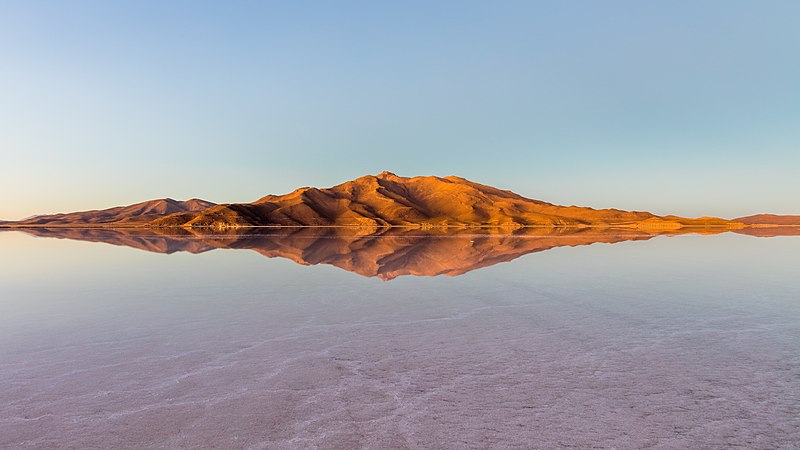
Español: Montañas y sus reflejos rodeando el salar de Uyuni durante el amanecer, Provincia de Daniel Campos, Departamento de Potosí, suroeste de Bolivia, no lejos de la cordillera de los Andes. Este salar es, con una superficie de 10,582 km2, el mayor del mundo, y ofrece durante la época de lluvia (diciembre-febrero) espectaculares reflejos en el agua.
English: Mountains and reflections surrounding the Uyuni salt flat during sunrise, Daniel Campos Province, Potosí Department, southwestern Bolivia, not far from the crest of the Andes. This salt flat is, with a surface of 10,582 square kilometers (4,086 sq mi), the world's largest, and during the rain saison (December-February) offers spectacular reflexions.
Polski: Widok o wschodzie słońca na góry (oraz ich odbicia) otaczające solnisko Uyuni (hiszp. salar de Uyuni) położone w prowincji Daniel Campos w departamencie Potosí, w południowo-zachodniej Boliwii, niedaleko Andów. Solnisko ma powierzchnię 10.582 km² i jest największym solniskiem na świecie. Podczas pory deszczowej (grudzień – luty) można tutaj oglądać spektakularne odbicia gór w wodzie.
Português: Montanhas e seus reflexos em torno do salar de Uyuni durante o amanhecer, província de Daniel Campos, departamento de Potosí, sudoeste da Bolívia, não muito longe da cordilheira dos Andes. Este deserto de sal é, com uma superfície de 10,582 km2, o maior do mundo, e oferece durante a estação chuvosa (dezembro a fevereiro) reflexos na água espetaculares.
Čeština: Hory obklopující solnou pláň Salar de Uyuni za východu slunce, Potosí Department, jihozápadní Bolívie. Jde o největší solnou pláň na světě s plochou 10 582 km2, v období dešťů (leden - únor) nabízí mimořádné zrcadlové pohledy okolní krajiny.
Italiano: I monti che circondano la salina di Salar de Uyuni in Bolivia. Con una superficie di 10 582 kmq è la più grande salina del mondo.
Македонски: Планините околу во Ујунската Солница на изгрејсонце. Покраина Даниел Кампос во департманот Потоси, југозападна Боливија, недалеку од Андите. Ова е најголемата солница во светот.
Nederlands: Bergen, die worden gereflecteerd in de Boliviaanse zoutvlakte Salar de Uyuni tijdens zonsopkomst. |
||||||||||||||||||||
| Musi | |||||||||||||||||||||
| Mabviro | Basa rangu | ||||||||||||||||||||
| Munyori |
|
||||||||||||||||||||

Assessment
|
This image was selected as picture of the day on Wikimedia Commons for 30 August 2016. It was captioned as follows: English: Mountains surrounding the Uyuni salt flat during sunrise, Daniel Campos Province, Potosí Department, southwesten Bolivia, not far from the crest of the Andes. This salt flat is, with a surface of 10,582 square kilometers (4,086 sq mi), the world's largest, and during the rain season (December-February) offers spectacular reflections. Other languages:
Čeština: Hory obklopující solnou pláň Salar de Uyuni za východu slunce, Potosí Department, jihozápadní Bolívie. Jde o největší solnou pláň na světě s plochou 10 582 km2, v období dešťů (leden - únor) nabízí mimořádné zrcadlové pohledy okolní krajiny. English: Mountains surrounding the Uyuni salt flat during sunrise, Daniel Campos Province, Potosí Department, southwesten Bolivia, not far from the crest of the Andes. This salt flat is, with a surface of 10,582 square kilometers (4,086 sq mi), the world's largest, and during the rain season (December-February) offers spectacular reflections. Español: Montañas y sus reflejos rodeando el salar de Uyuni durante el amanecer, Provincia de Daniel Campos, Departamento de Potosí, suroeste de Bolivia, no lejos de la cordillera de los Andes. Este salar es, con una superficie de 10,582 km2, el mayor del mundo, y ofrece durante la época de lluvia (diciembre-febrero) espectaculares reflejos en el agua. Italiano: I monti che circondano la salina di Salar de Uyuni in Bolivia. Con una superficie di 10 582 kmq è la più grande salina del mondo. Nederlands: Bergen, die worden gereflecteerd in de Boliviaanse zoutvlakte Salar de Uyuni tijdens zonsopkomst. Polski: Widok o wschodzie słońca na góry otaczające solnisko Uyuni (hiszp. salar de Uyuni) położone w prowincji Daniel Campos w departamencie Potosí, w południowo-zachodniej Boliwii, niedaleko Andów. Solnisko ma powierzchnię 10.582 km² i jest największym solniskiem na świecie. Podczas pory deszczowej (grudzień – luty) można tutaj oglądać spektakularne odbicia gór w wodzie. Português: Montanhas e seus reflexos em torno do salar de Uyuni durante o amanhecer, província de Daniel Campos, departamento de Potosí, sudoeste da Bolívia, não muito longe da cordilheira dos Andes. Este deserto de sal é o maior do mundo e oferece, durante a estação chuvosa (dezembro a fevereiro), reflexos na água espetaculares. Македонски: Планините околу во Ујунската Солница на изгрејсонце. Покраина Даниел Кампос во департманот Потоси, југозападна Боливија, недалеку од Андите. Ова е најголемата солница во светот. |
Kurezinesa
Another one of my pictures: Want to see more works of mine? click here |
Under this condition:
Please, use this work legally fulfilling the terms of the license! Please, let me know if you use this work outside Wikimedia Commons sending me an email on Furthermore, if you:
please, do not hesitate to contact me. |

|
Please do not overwrite the author's version with a modified image without discussing with the author. The author would like to make corrections only from the uncompressed RAW file. This ensures that changes are preserved and are based on the best possible source to achieve a high quality. If you think that changes are required, please, get in touch with the author. Otherwise, you can upload a new image with a different name without overwriting this one. Use {{Derived from}} or {{Extracted from}} for this purpose. |
- Wakasungunuka:
- kugova – kucheza, kugovera ne kutumira basa
- kurhimikisa – kugadzirisa basa
- Pasi pemamiriro anotevera:
- Uzikano – Unofanhira kupa kiredhiti yakakodzeka, ipa kochekero yekune rezinesi, uye ratidza kana zvichinjirudzo zvaitwa. Ita sokudaro zviichienderana nenzira inonzwisisika, asi kwete nenzira ingaratidze zvekudii kuti murezinesi anokutsigira kana kushandiso kwako.
- gova saizvo – If you remix, transform, or build upon the material, you must distribute your contributions under the same or compatible license as the original.
Nhoroondo ye fayera
Dzvanya pa musi/nguva kuti uringe fayera sekuoneka kwaraita panguva iyoyo.
| Musi/Nguva | Mfananoudoko | Mitandu | Mushandisi | Komenda | |
|---|---|---|---|---|---|
| parizvino | 19:23, 14 Kubvumbi 2016 | | 8,654 × 4,868 (9.74 MB) | Poco a poco | Spots |
| 19:08, 14 Kubvumbi 2016 |  | 8,654 × 4,868 (10.81 MB) | Poco a poco | Crop | |
| 18:58, 19 Kurume 2016 |  | 8,654 × 5,431 (7.61 MB) | Poco a poco | User created page with UploadWizard |
Kushandiswa kwe fayera
There are no pages that use this file.